Pilots must receive and document attendence at a flying safety briefing prior to their first flight of the year. Pilots & aircraft owners must have proof of acceptable insurance & sign the ASI Waiver of Liability | |||||||||||||
|
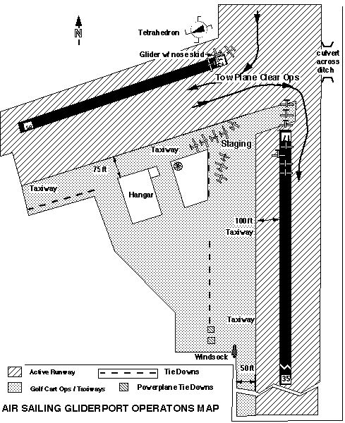
Airfield Summary Field Operations Guide Pilots should familiarize themselves with Air Sailing's operating rules and policies before arriving at the gliderport by reading the ASI Operating Procedures Airfield Information Air Sailing Gliderport is located in Washoe County, Nevada approximately twenty-six miles north of Reno-Tahoe International Airport and eight miles west of Pyramid Lake. Field Elevation: 4300 ft. MSL Latitude: N39 degrees 52 minutes Air Sailing has three usable runways and an auxiliary strip. Two runways are partially paved. The paved areas can be used for takeoff and/or landing:
All runways are kept in very good condition. Runway 21L (the generally the favored runway for landing in the afternoon) is wide enough to land several gliders abreast. Typically, we take off on the paved portion of the runways, and land in the adjacent dirt. A parallel dirt strip on 03L/21R is primarily used by the towplanes to stay clear of staging gliders, but is available for glider use as needed. |
|||||||||||||
|
|||||||||||||
|
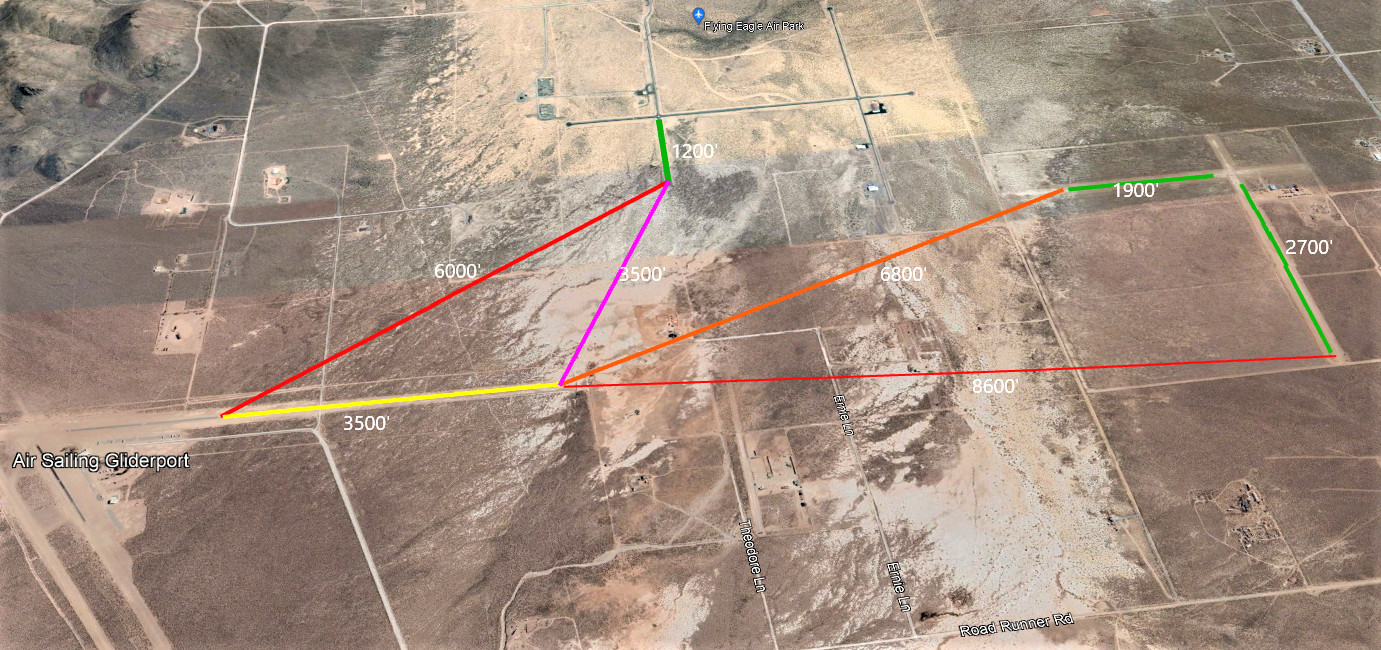
Field Layout Distances to Neighbors |
|||||||||||||
| Insurance Requirements | |||||||||||||
| Truckee Airport & Tower Info | |||||||||||||
|
|
|||||||||||||
Frequencies Used |
|||||||||||||
Multicom 122.9 below 7000 ft MSL NorCal Tracon 126.3 above 7000ft MSL Air-to-air (optional/encouraged) 123.3 above 7000 ft MSL Pilots of aircraft arriving or departing Air Sailing Gliderport, or conducting other than arriving or departing operations below 7000' MSL, should monitor and communicate as appropriate on our MULTICOM frequency 122.90 MHz within 10 miles of the Gliderport unless required to do otherwise by NorCal. Radio communications between glider and tow pilot is required before all takeoffs at Air Sailing. Pilots of aircraft arriving or departing Air Sailing Gliderport may obtain the current information from Reno ATIS frequency 135.8 MHz for local NOTAMs and the active runways at Reno/Tahoe International Airport. |
|||||||||||||
Transponders |
|||||||||||||
ADSB is required in and around Reno Class C. Use of Mode C transponders is strongly encouraged in the Reno APC area (50 nm). A nationwide transponder code (1202) for gliders "not in contact with ATC" is now in effect. |
|||||||||||||
Flight Service Station |
|||||||||||||
Reno-Tahoe Airport (on field): 122.5, 122.2 (775) 858-1300 |
|||||||||||||
Local Weather Advisories |
|||||||||||||
|
Stead AWOS 135.175
Reno-Tahoe ATIS 135.8 On field weater monitor: Sign up for a free account at Weather Link and search Weather Link for "AirSailing Gliderport" You can use the "Davis Instruments" WeatherLink app on iOS (there may be a app for other platforms too) There is a Monitor Console next to the VHF radio in the clubhouse too. |
|||||||||||||
Cautions |
|||||||||||||
|
|||||||||||||
Invoices are mailed periodically and are due upon receipt. | |||||||||||||